Mount Williamson's West Face | TRVRS Outdoors

Lake Helen of Troy and the Williamson Bowl from the West Face of Mount Williamson.
Overview
California's second tallest peak and the sixth tallest peak in the contiguous United States, Mount Williamson (14,379 ft.) stands tall above the John Muir Wilderness of the Inyo National Forest. Although the mountain is far less popular than its taller neighbor to the south (Mt. Whitney), its easiest approach includes a relatively steep class 1-2 ascent for over 11 miles and 7,000 feet of vertical gain just to reach Shepherd Pass. After which point the trail disappears and far more difficult terrain emerges for the remaining 3 miles and 2,700 feet to the summit. With all of its difficulties, the route features immaculate views of several alpine lakes leading up to the Williamson bowl which is a spectacle in its own right and the peaks massive summit plateau soars over Sequoia National Park.


Google Earth overview of route - Mount Williamson via Shepherd Pass Trail.
August 2nd, 2018 - I awoke at 5:00 AM with the intention of heading straight to the small town of Independence only to immediately fall back to sleep until 8:00AM, a hesitation I was not used to on these treks. Hours later, I would make it to the trail head and it would only be thanks to my vehicles high clearance. I read that some hikers had made it in a Sedan but it wouldn't be something I would recommend since the OHV roads were pretty mangled in some sections. By the time I parked another instance of hesitation came over me and I sat near the car for nearly 15 minutes until I realized I may have been a bit more fearful than my previous solo outing to Deerhorn Mountain just weeks prior. The lack of clarity I was experiencing was only matched by the smokey mountain views caused by fires in the Yosemite Valley and I needed a minute to clear the haze. Finally at 12PM, I made for the trail in good spirits.

Foothill Road - Independence, California.
Shepherd Pass Trail
The first mile (660 ft. vertical gain) brought on four creek crossings and storm clouds. The abundance of water made filtering more seem unnecessary and so I continued along the path with just under a quarter of a handheld bottle filled. I spent the next 2.5 miles (and an additional 2500 ft vertical gain) trudging up an endless series of switchbacks. A light mist became drizzle and I threw on a rain cover. Minutes later, the drizzle became rain and I added a silly looking plastic pancho. With each additional layer came another short interruption in my moving effort. By the time I was walking again the rain stopped and I muttered to myself "...of course". Finally I reached the Symmes Creek saddle where I spent a few minutes reorienting myself before continuing along the obvious and now much more relaxed descent toward Shepherd Creek.


Creek crossing along the Shepherd Pass Trail.
Relief Near Mahogany Flat
My pace seemed to coincide with precipitation. As I began jogging into the canyon, booming thunder and showers filled the air. I took a break under a tree to evaluate my situation and eventually decided against turning back. The only fear I had at this point was a lightning strike and logic told me that moving further into a canyon didn't encourage the likelihood of such an event. A collective 5.5 miles and 4020 ft. of vertical gain brought me to another creek crossing and a clearing in the clouds simultaneously. The view up to Mt. Keith here was incredible and I had been so grateful to find water and be rid of it at the same time.


Looking up at Mount Keith from Shepherd Creek.
Anvil Camp
A few more switchbacks brought me to Anvil Camp; a lush campground situated along the convergence between Shepherd Creek and its trail . A group of backpackers were sitting in a circle preparing dinner. During our brief interaction they mentioned that they were attempting Tyndall and Williamson, but the rough weather drove them to pitch camp. I made no mention of my poor decision making during the storm and continued toward the destination.


Approaching Anvil Camp after a few long switchbacks.
The Pothole
I began to feel my pace slowing after a 5,700 foot ascent over 8.2 miles and Shepherd Pass still wasn't even visible. One more shelf just past the Pothole would lead to the bottom of the pass and I could see the Southeast ridge of Junction Peak descending toward my eventual victory. I scarfed down a Luna Bar and filtered some water before ascending the shelf. Eventually I reached the bottom of the pass and became nervous of the fact that I didn't see a trail snaking along the talus field. However as I continued to walk, the path emerged.


Panorama of the Shepherd Pass Trail near the Pothole.
A Morbid Ascent
Leaving the timberline is always bittersweet, but the trade off for the relaxing sound of rushing water and shade inside of the canopy is almost always an epic view of everything one has conquered and an infinite amount of everything one hasn't. My posture was screaming that I was ready to be done and just as my shoulders sunk further into my chest, a putrid smell sent them racing back to catch up with my nose. The talus field was riddled with flesh and bone and I realized that I was surrounded by the remains of over two dozen deer. At first I was under the impression that the herd must have been wiped out during an avalanche, but later read that it was possible for them to have fallen one after another while trying to descend the perhaps icy slopes above.


Deer remains close to Shepherd Pass.
Shepherd Pass
At 6:30 PM, I reached Shepherd Pass (11 miles and 7,000 vertical feet later) and although I had plenty of time until sunset, I decided that my original goal to spend the night near Lake 12247 may have been a little ambitious. I dropped my pack at the first site I saw and let out a sigh of relief. Williamson was still nowhere to be found while Mount Tyndall's north west ridge dominated the landscape. Just twenty feet away, a women sat against a boulder with her legs extended and appeared to be writing in a journal. A brief interaction turned into a full on interview after she mentioned that she had just come back from climbing Williamson. I apologized for the interrogation and continued pitching camp. The rest of the evening would be spent making estimates on completion time over a cold slice of pizza. I set my alarm for 4:00AM and fell to sleep.


Mount Tyndall from my campsite at Shepherd Pass.
The Williamson Bowl
August 3rd, 2018 - Even after a mediocre night of sleep, I managed to get up and out of bed pretty quickly. An alpine start is always a rewarding and productive introduction to the day, but credit will also have to go to the morning chill at 12,000 ft. By 4:30AM I was on the trail. A mile later, I began a rocky descent into the Williamson Bowl in perfect time for twilight. The small goals I created for myself during the previous evening allowed for a quick pace and the only time I stopped was to observe potential routes. Fortunately, cairns dotted the talus field as reassurance to the already straightforward route which essentially stayed to the highest points between each body of water I passed. I reached the base of the mountain after traveling along teetering boulders for 2 miles and just under 1,000 feet of gain (13 miles, and 8,000 ft. collectively) and short break allowed me to enjoy a well deserved display of alpen glow against the eastern face of both Mount Tyndall and Cal Tech Peak with my breakfast.


Panorama of the Williamson Bowl and Lake Helen of Troy.
The West Face
The final ascent to Mount Williamson would prove difficult, but not out of my skill set. Just 500 feet above the base were the infamous black stains that serve as a way point for the route along Williamson's west face. From the top of the stains, I would continue to climb slightly left toward the largest chute between two obvious pillars . An additional 1,200 feet in under a half mile would bring me to the next point of interest. The chimney is a fifty foot exposed class 3 crack up to the summit Plateau. I spent about ten minutes looking for another route up since I had not seen photos of it before my arrival and it honestly looked a little intimidating but after a short internal dialogue of encouragement, I began a careful ascent.
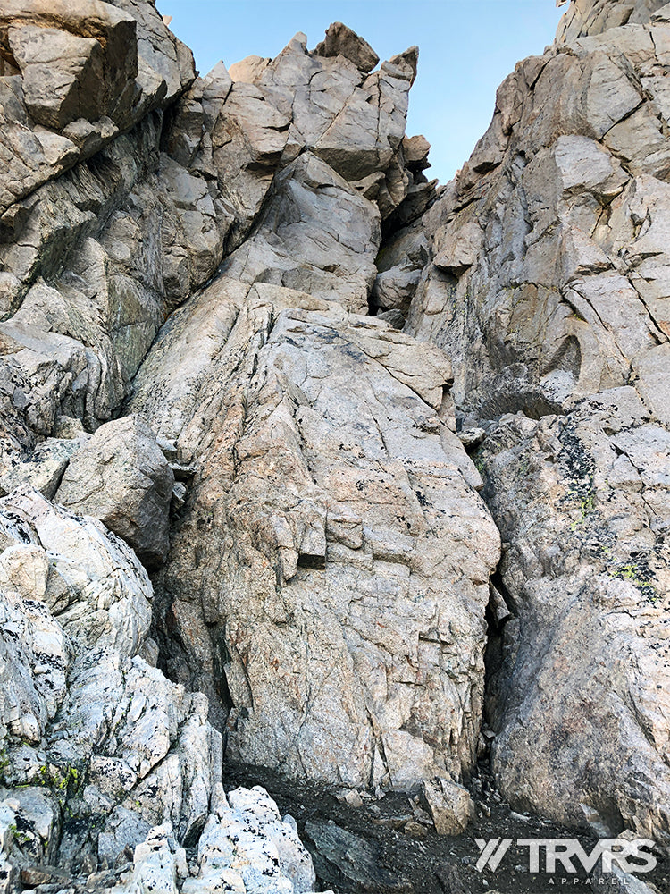

Looking up at the Class 3 chimney (large crack on the center right).
Williamson Summit
The long approach was finally over. I reached the massive summit plateau and began the short scramble to the peak where I found the summit register had been left open and was completely soaked from the storm. I spent a few minutes enjoying the view of Trojan Peak and Mount Bernard to the immediate south, with Russell, Carrillon and Whitney further back while the ridge line to the North featured a hazy view of Kings Canyon National Park and beyond.
This would be the shortest amount of time I had ever spent on a Sierra peak. I had another protein bar and made way for the chimney when I realized I should probably check my phone for cell service. Sure enough, I was able to video chat with my mom and text all of my emergency contacts that I was on my way back down. I reached Shepherd Pass at 10:30AM where I toyed with the idea of knocking out Tyndall's second rib but ultimately decided that I didn't want to be on the trail after dark. A strong jogging pace brought me back to the car at 4:00PM after one of the most refreshing creek baths I had ever experienced. Another 14er in the bag!


Southern view of Sequoia National Forest and the John Muir Wilderness.
MORE INFO
Total Distance (from trail head to summit) : 14 miles
Total Elevation (feet): 10,500 feet
Trail Difficulty: Hard.
- Class 1 heavily trafficked trail for everything up to Shepherd Pass (mile 11 to be more exact).
- Class 2 fore the majority of the Williamson Bowl.
- Upper Class 2 in the chute and 50 foot exposed Class 3 ascent for the chimney.


Leave a comment