Sorry, the content of this store can't be seen by a younger audience. Come back when you're older.
Cottonwood-Marble Canyon Backpacking Loop | Death Valley
by
Ricardo Soria
OVERVIEW
During the summer, the Sierra Nevada is the ultimate outdoor experience for the hiker in California. In the winter and early spring however, harsh conditions and high altitude make the Sierra a little more difficult to explore even outside the boundaries of a ski resort. Backpackers are left to seek out lower elevations, and what better location than the one that is touted for being the lowest point in the United States. Death Valley National Park spans three thousand square miles of desert landscape mostly inside of Inyo County, paralleling the California/Nevada border. While Death Valley is known for being consistently recorded as one of the hottest places on Earth during its long summer season, its more hospitable winters make it a great destination for backpacking.
In the heart of the Death Valley National Monument, between the Last Chance Range and Mesquite Flats, lies the Cottonwood Mountains. Within this mountain range is a 32-mile backpacking loop that can be accessed via Cottonwood Canyon, near Stovepipe Wells. The Cottonwood Marble Canyon Loop ascends the entirety of Cottonwood Canyon before descending into Deadhorse Canyon, and finally Marble Canyon. This route features some incredible geological features, petroglyphs, and scenic desert landscapes. With some good timing and luck, one might also find running waterfalls, and wild horses.
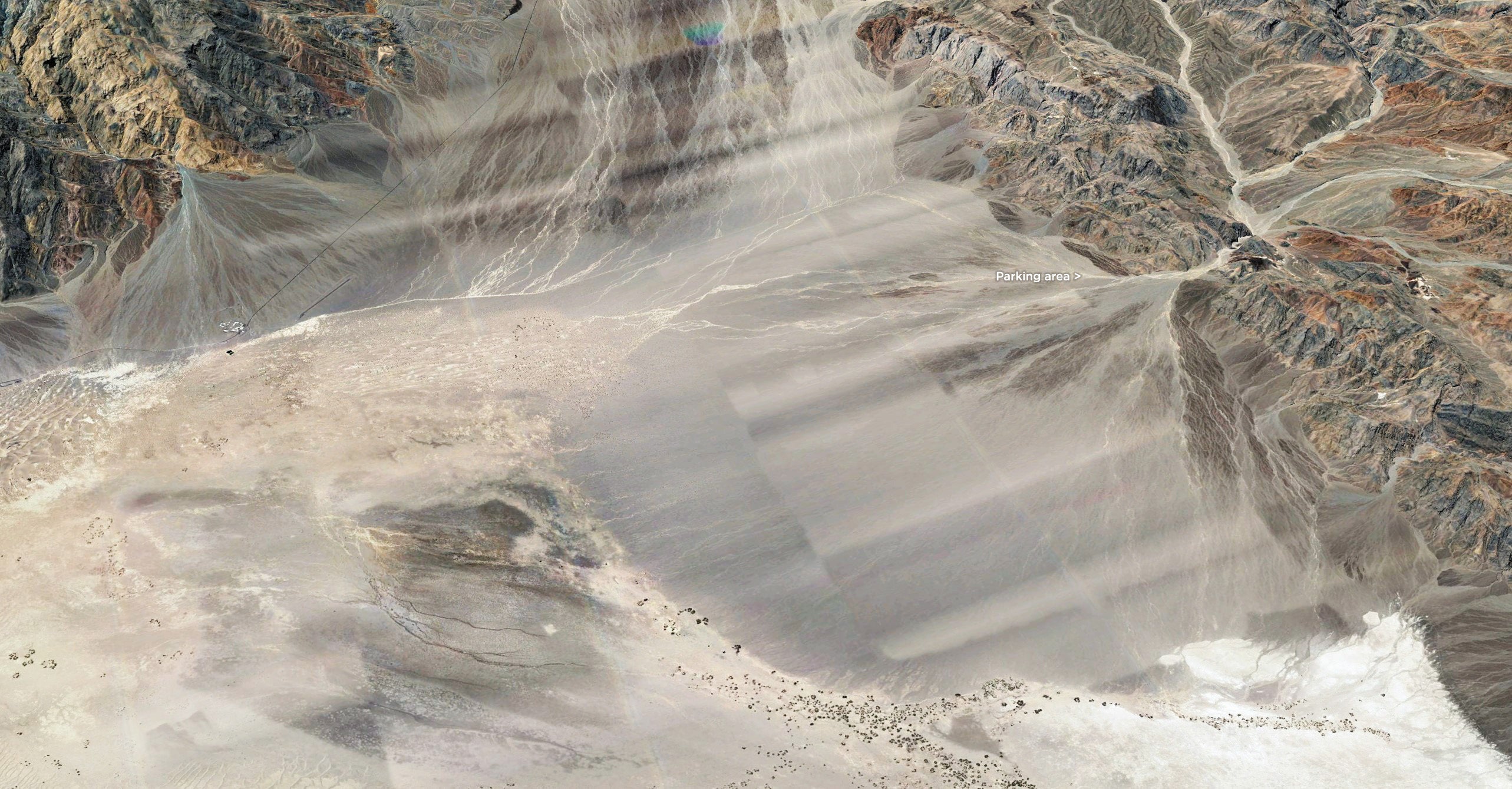
Google Earth overview of the Cottonwood-Marble Loop.
DISCLAIMER
There are a handful of cross country hikes here in the Southern California Wilderness that push the limits of the word "adventure" for several reasons. They are extremely remote locations that most people will never have the pleasure of seeing. A consequence of their isolated location is that rescue is highly unlikely in the case of an emergency.
That being said, it is the responsibility of the few that are capable of reaching these locations to practice safety when traveling to these places.
Double and triple check your supplies (especially water).
Check weather conditions the morning of your hike before you lose cell service.
TRVRS Outdoors is all for encouraging new and exciting adventures, but part of the adventure is doing adequate research ahead of time to assure a safe and fun trip which is why we've decided to document these back country hikes. Stay safe!
PREFACE
Jeremy obtained a permit months prior to this outing and while we spoke about the trek casually, a new job and simultaneous life stress made scheduling difficult for me. We wouldn't commit until a week and a half before the permit date. Fortunately, Jeremy had very clearly communicated the route logistics as well as its difficulty. The plan was to leave Friday afternoon and arrive at the trailhead in time for a nightcap and some dinner. This would allow us to have an early start ascending the bulk of Cottonwood Canyon on Saturday and then descend all of Deadhorse/Marble Canyon on Sunday. We may have arrived early judging by how many nightcaps we had time for...
COWBOY CAMPING THE ALLUVIAL FANS
The bulk of the drive to Stovepipe Wells was at night, so waking up in a parking area above an alluvial fan the following morning was pretty incredible. Right out of the sleeping bag at my six o'clock was a vast expanse of desert landscape with Stovepipe Wells and the Mesquite Flat sand dunes below. The Grapevine and Funeral Mountains filled the background and the sunrise had just begun to break.
I managed to uproot myself and observed the cluttered car. It was pretty unusual that neither of us had put a single morsel of effort into keeping organized the previous evening to the benefit of "future us", so packing was a bit of a struggle. However, the lack of vertical gain in our itinerary meant we could probably cruise through the bulk of the miles relatively quickly. We shared some instant coffee and got to work.
Hotel window view in the morning.
Cottonwood mountains and the parking area above Stovepipe Wells.
COTTONWOOD CANYON'S GRAND ENTERANCE
Saturday, February 4th, 8:13 am -- Our route began along the Cottonwood Canyon fire road where signage indicated its closure to vehicles. A mile later, we reached what I call the Grand Entrance. The front range of the Cottonwood Mountains stood thousands of feet above our heads without so much as an accessible pass in either direction for miles. And yet, at the top of this massive alluvial fan that fed several miles of sand dunes stood a void in the mountains which granted access to our route and offered a small sample of what water can do when there isn't any vegetation or soil to soak it up. It was unique to anything I had seen in my travels up to this point, but to be absolutely honest, I didn't fully grasp it until I opened up Google earth to write this report.
Satellite view of hiking route entrance.
Jeremy, near the end of the Grand Entrance.
COTTONWOOD AMPHITHEATRE
Location: 36.57999, -117.31160
After a quarter mile of winding around the canyon, we reached the valley that connected our loop and we could now more clearly capture our playground for the next two days. We followed the road for an additional 3/4 of a mile south to the Cottonwood-Marble loop junction. We moved further south and with the exception of Cottonwood Benchmark to the east, small hills surrounded a relatively featureless canyon. This allowed us to pound out some miles quickly and by mile six, we reached our first landmark. A large cavity in the canyon wall made a perfect amphitheater style cave with a sixty foot tall ceiling and incredible acoustics to match. The air inside was cool and small bits of debris from an illegal fire pit suggested it was quite the destination for groups.
We spent a few minutes making weird sounds for the cave to reverberate. This backfired and our anxieties got the best of us, so we decided to keep moving. With each step, the scenery became more dramatic and intense which seemed to parallel the depth of our conversations. By mile seven, we were once again surrounded by steep cliff walls in a now more narrow canyon.
Dry fall textures.
Walking along Cottonwood Canyon.
Cottonwood Amphitheatre. Human for scale.
REACHING COTTONWOOD ROAD'S END
Location: 36.57999, -117.31160
After climbing 2,100 feet in 8.5 miles, we were still pushing three miles per hour which was surprising considering the amount of short photo opportunities we had taken advantage of. This is right where things started to catch up to us. The day was beginning to warm and we started noticing the sporadic sandy sections along the path. They weren't notably difficult, just tedious enough to become a hindrance over time. We put additional effort into avoiding them and made a conscious decision to start looking for a place to take a break. Jeremy knew that this thought coincided with reaching tree line and an eventual spring, so we marched on.
Just shy of mile 10.5 we got eyes on water and it was flowing surprisingly well. We followed the trail further and the landscape gradually filled with vegetation. Our goal was to find a shaded place to sit by the water for a snack or seven. We found our desert oasis near our next landmark; Cottonwood Road's end.
The route, becoming a little more interesting..
A quick break near Cottonwood road's end.
Big canyon wall.
COTTONWOOD SPRING CAMP
Location:36.51193, -117.37821
We followed the creek trail and the terrain quickly transitioned from a dusty desert path to a muddy swamp (go figure). We fought through some fallen branches and eventually got high up enough on western side of the creek to sidehill for the remainder of this section. We would alternate between these two styles of terrain for the rest of the day. By mile 13.5, after climbing 3,300 feet, we reached another swamp. It would turn out to be the Cottonwood Canyon final boss. When Jeremy originally mentioned tree cover, I assunmed we'd be walking along a well kept single track path under a lush canopy. Instead the path was three inches of mud and the canopy was just a series of unbreakable twigs that were either just high enough to trip us or just low enough to get caught on our clothing/packs.
About half way through this debacle, Jeremy mentioned that the trip report noted a large hill right before camp. In our desperation to be finished, we began expecting every slight upward slog to be the last one, which only amplified our misery.
3:08 pm -- Eventually, we left the tree line on the far south side of the creek and reached the last "last hill". At the top, we snapped a few photos and rounded the south west side of the tree line where we reached camp. The site was large, shaded, and mostly free from wind exposure. We decompressed with a lukewarm beer while exploding our packs and starting the evening chores.
One of the less messy sections of the creek bed.
Cottonwood springs camp site. Probably could have fit three to four tents here before it started getting uncomfortable.
Sunset from camp.
DAY 2: THE TOP OF COTTONWOOD CANYON
Sunday, February 5th, 6:50 am -- I awoke to the dreadful thought of unzipping my sleeping bag to the cold and was pleasantly surprised by how warm it was compared to the previous evening. We spent the last hour before bed using our sleeping bags as jackets. The water from Cottonwood Spring had a strange taste and color. It was peaty and had a yellow tint to it, like a cheap scotch.
By 7:30 am, we were on the trail. We followed the route northwest from camp on a gradual ascent into the far reaches of Cottonwood Canyon. To our right was a ridgeline paralleling our route that lead to a 5,900 foot peak called Canyon Point. Our exit for the canyon would be somewhere past this peak. To our left was a massive open valley and a series of unnamed peaks off in the distance. I noticed we were stepping over animal tracks as well as fresh scat and started keeping an eye out for wildlife. We might have walked a mile and a half before we got eyes on two white figures in the distance.
The main trail here seemed pretty sandy, so we decided to stay high in the basin and walk directly toward the white figures to get a closer look. It turned out to be two white feral horses (which I read are not considered "wild" since they or their ancestors were once domesticated). We got as close as fifty feet from the horses before we decided that getting any closer would be invasive. We took our time snapping some photos and continued toward the saddle.
Filtered canyon water (left), store bought (right).
Clouds along the Hunter mountains to the southwest.
Hiking toward the top of the canyon, Canyon Point Peak in the background.
Feral horses with Canyon Point in the back.
Close-up of these two beautiful white feral horses.
REACHING CANYON POINT SADDLE
Location:36.55614, -117.39650
We were really excited to see some wildlife in such a remote place, but leaving the main trail opened us up to catch some rolling hills along the way. They were mostly negligible, but after the fifth or sixth unnecessary rolling hill, I was ready to get back to the main trail. We eventually reached the unnamed pass that we'll call Canyon Point Pass for the purpose of this report. It happened to be the highest point in our trip, so we took a short break here to soak in our surroundings. Just behind the low point in the canyon stood the Grapevine Mountains with an acute Thimble Peak standing out along its crest.
Backpacker, approaching the pass.
REACHING DEADHORSE CANYON SPRINGS
Location:36.57360, -117.37814
From the top of the pass, we descended a use-trail along sandy slopes. The route was tame and well worn. There were a half dozen animals worth of white bones on the two mile stretch down to Deadhorse Canyon (...because, foreshadowing). A short hundred foot ascent brought us to a really steep final descent into our canyon. The route was steep, but sandy and we made quick work of the descent. We reached the junction for Deadhorse Canyon and our spring, which had a strong flow. Neither of us needed water, but we took a short snack break at the junction anyway because that's what you do when you see water in a place that seemingly has none.
Backpacker descending towards Deadhorse Canyon. Thimble Peak is the pointy thing (center left).
A little closer to Deadhorse Canyon.
I can only assume these belong to a dead horse.
Jeremy, getting ready for lunch.
THE MARBLE-DEADHORSE CONFLUENCE
During our Deadhorse Canyon stint (roughly mile six for the day), we reached a fifteen foot impassable dry fall. Backtracking a bit allowed us to hang around the left side of the canyon to bypass it. Shortly after, we reached another impassable waterfall and judging by Jeremy's confusion, the trip report didn't mention this one. Our guess was that it was usually dry and possible to descend via a short rock scramble.
Two gentlemen were climbing Marble from the bottom at the exact same time we arrived. We collectively stood around in confusion before Jeremy and I started making work of finding an alternate route. Once again, we backtracked and shot up on the left side of the canyon following a use trail. From the top, we could clearly see that people had been using this route, but we descended the steep, crumbly mess of dirt ridden granite one at a time.
Everything past the falls was pretty tame and we reached the Marble Canyon confluence right around mile seven. I have to admit that after reading other reports, this is where I imagined people seemed really hung up on how unnecessary completing the loop is (vs. doing an out-and-back hike straight to the narrows). Winding around the canyon brought on a feeling of de ja vu, as each segment resembled the last. I kept quoting tropey movie lines to Jeremy.
"We're going in circles, man!"
Jeremy, talking to the other hikers (out of shot). The route we descended (background). Not so dry falls (center left).
THE MARBLE CANYON NARROWS
Location:36.60590, -117.33946
At around mile ten for the day, we reached some smooth rock formations that seemed prime for petroglyphs on the right side of the path. I scanned around and sure enough, there they were. Trying to decipher them was fascinating, but the feeling of wonder was abruptly followed by disappointment after seeing modern graffiti scraped in the adjacent rocks.
Just a quarter mile past the petroglyphs, we reached the most obvious climax of the trip. I had yet to see anything quite like the Marble Canyon narrows that wasn't in photos and I was pretty impressed. Smooth granite walls shot up a hundred feet on both sides of our path. The mood quickly transitioned from exposed, hot, and yellow to shaded, cool, and blue.
We spent the good side of a half-hour soaking in the narrows (along with the remainder of the whiskey). About 1.5 miles after leaving the narrows, we reached signs of a road. I initially assumed that this meant the trail would get much easier. It didn't. The road was sandy, and while there were flat compacted dirt shelves on either side, we had to continuously navigate over small tedious rocks to reach a short segment of relief. I was definitely getting tired.
Close-up of some petroglyphs.
Hiker below striped rock formations.
Jeremy, in the Marble Canyon narrows.
RETURN TO STOVEPIPE WELLS
We were both very excited to reach the Cottonwood-Marble Canyon junction, where we were back on an actual fire road. During the last mile, we ran into a couple that were just beginning their journey on the same loop. We shared all of our trail beta and wished them a safe trip. We were on the trail for almost eight hours before making it back to the car where we closed out our Death Valley tour with a baby wipe and beer at Stovepipe Wells. We had a full walking work-shift and we still needed to endure a four hour drive home. I was extremely grateful that Jeremy took on the driving duties and organized another amazing trip. However, after finding out that three of his car's lug nuts came off during our trek, I think I'll be driving for the next one.
MORE INFORMATION
Distance (miles)
Day 1: 15.11
Day 2: 16.94
Elevation Gain/loss (feet)
Day 1: +3,296' / -394'
Day 2: +1,837' /-4764'
Route Difficulty: Moderate
Driving conditions: Sandy road from Stovepipe Wells to trailhead. 4WD vehicle recommended (contact ranger before driving out).
Terrain Encountered:Class 2. One class 3 segment descending dry falls (avoidable). Dirt roads, single track paths, downed trees along muddy creek bed, side-hilling, sand. Lots of navigation.


Leave a comment