Background of the Pfiffner Traverse
The Pfiffner Traverse is a 78 mile cross country backpacking trek created by Gerry Roach his late friend Carl Pfiffner. It was later modified by Andrew Skurka to the popularized thru-hike it is today. The route closely follows the Continental Divide from Milner Pass to Berthoud Pass in Colorado's front country and crosses the Rocky Mountain National Park, Indian Peaks Wilderness, and James Peak Wilderness areas.
Preface
While cross country adventure has always been an important part of my outdoor diet, I didn't actually know that the Pfiffner Traverse existed until this year. I had twice section hiked the Sierra High Route in 2018-19 and was preparing to
complete the SHR northbound in its entirety in from September 8th-18th of 2020. Even as far back as late August, air quality along the SHR was a concern due to the Moraine Fire at the Southern Terminus (where I would start). However it wasn't until September 7th that I cancelled my flight due to the massive expansion of the Creek Fire further north. Days later, the entire National Forest System closed in California.
I spent the next week or two closely monitoring the Creek Fire updates in a desperate attempt to hold things together. Between training up to sixty miles per week, literally rewriting the Secor book into a spark notes version of itself, and creating an extremely detailed itinerary for the outing on Caltopo, it was depressing to see my plans go up in literal flames. Acceptance set in, and I decided to count my blessings. I began looking more closely into Colorado's Pfiffner Traverse after downloading
Andrew Skurka's guide. After all, most of my peak training days were spent backpacking segments of the route to better acquaint myself for a future attempt.
Just days before the outing, a friend named Cameron reached out with an alternate plan for the Sierra High Route. He had been coordinating a southbound attempt of the SHR just weeks earlier, so his mutual disappointment in regards to the forest closure came as no shock. Not knowing what to expect from the Pfiffner Traverse and having done far less research, I decided to invite him along. My experience on portions of the route as well as the printed
Skurka Guide map set and a Caltopo GPX file I put together was all we had to get us across the route. Two days later, we were both at the Kawuneeche Visitor Center being scolded by a Forest Ranger for our lofty goals.
DISCLAIMER
There are a handful of cross country hikes in the Colorado wilderness that push the limits of the word "adventure" for several reasons. They are extremely remote locations that most people will never have the pleasure of seeing. A consequence of their isolated location is that rescue is highly unlikely in the case of an emergency.
That being said, it is the responsibility of the few that are capable of reaching these locations to practice safety when traveling to these places.
TRVRS Outdoors is all for encouraging new and exciting adventures, but part of the adventure is doing adequate research ahead of time to assure a safe and fun trip which is why we've decided to document these back country hikes. Stay safe!

Ricardo "RJ" Soria (me) and Cameron Hummels (right), at Milner Pass.
Day 1, Milner Pass to Haynach Lakes
9.5 miles | +3,200 feet | -3200 feet
Time on feet: 06:25

Sunday, September 20th -- We left the trail head at 4:11 PM. CalTopo estimated Hayhach Lake to be roughly 7 miles form the northern terminus (Milner Pass) and I for some reason assumed this to mean that it would be an easy walk. I carried this careless attitude all the way to the top of Mount Ida at 6:45 PM. We scrambled over the peak and looked South at what we now knew to be Haynach Pass off in the distance. All that stood between us and our goal was about two miles of mixed talus and tundra, not including whatever was out of sight. The sun dimmed beyond the horizon taking a little bit of our spirits with it. Thankfully, we had headlamps.

Cameron, standing along the Continental Divide.

Looking down at Highest Lake from Chief Cheley Peak.
We reached the Pass a little before 8 PM and took our time descending the cocktail of scree and talus into Haynach Lakes basin since there was still no significant change in the weather. Maybe one hundred feet before reaching the grassy meadows, Cameron took a spill and called out that he broke his finger. I doubled back to offer assistance, but quickly realized there wasn't much either of us could do. The function of both his hands would be critical to our success later in the trek. He would need to bail on the Pfiffner Traverse.


Camerons finger. Turned out to be dislocated, but the stories better this way.
Day 2, Haynach Lakes to East Inlet
18.9 miles | +5,200 feet | -5,300 feet
Time on feet: 09:21

Monday, September 21st -- I awoke to the sound of my alarm clock and judging by the constant call-and-response of our rustling down bags throughout the night, Cameron and I had similar sleep habits in the back country. As I was packing, a woman and her husband strolled by and said "You're in our campsite." Confused, I looked over and said "we're in OUR campsite" Just then, I remembered that upon our arrival the night before we had stumbled upon another tent. We thought nothing of it since the Ranger had mentioned that there were two permitted sites within the designated camping area.
"Our permit was for the Haynach LLAMA site", I clarified.
The couple fired back, "That's what ours is for".
"Okay well. We have a permit too" I said, nonchalantly.
They both paused, then the man said "No you don't" and they both walked away.
I scoffed, "Okay have a good day and send a Ranger over if you seen one."
"We will!"
Cameron murmured from his tent, "Why didn't you show them the permit."
"We don't need to show them shit."
I continued packing my things while we went over Cameron's game plan. He would bail via the Tonahutu Creek trail. From there he could get back to the Ranger station where he could hopefully find a ride along Highway 34 to reach his car at the Southern terminus. With any luck, both of us would find a way back to Berthoud Pass.
Reaching North Inlet
By 7:39 AM, I left camp and moved south along the remainder of the Haynach Lakes trail toward the Tonahutu Creek trail. Where the trail leaves the creek was a sign that read "the mountain doesn't care". I took a long mental note of our toxic relationship then sighed and kept walking.

Looking NE from Ptarmigan Pass.
Within two hours, I reached Ptarmigan Pass. The glacier below contoured into a perfect bowl and I pictured a sweet winter ascent from the Lakes below. Further south, I saw the same two goblins from camp. I caught up to them along the upper North Inlet trail and this time their greeting was far more pleasant.

Looking SW into Hallett Creek & the North Inlet.
I was fired up for the rest of the descent into Hallet Creek and eventually reached the Lake Nanita trail. Grateful to be on familiar territory, I made sure to have a snack before the day's next big ascent. Nokoni and Nanita Lakes stood over 1,200 feet from the creek they fed, and offered some exceptional views. I was eager to take some photos near Nanita with better sunlight than a previous visit. The trail began to fade near Nanita's inlet and a 500 foot climb through mostly soft meadows placed me just below the northeast face of Andrews Peak.

Ptarmigan Mountain as seen the Lake Nanita Trail.

Ptarmigan Mountain from Lake Nanita's outlet.

Looking SE toward Andrews Peak and Beak Pass.
Reaching East Inlet
Beak Pass was now in sight and just beyond its southern slope was the East Inlet, my next and final destination. Before leaving the high point, I took a minute to make note of landmarks surrounding my desired route and avoid unnecessary circuitous route finding later on, a convenience I would soon sorely miss.

Beak Pass from just below Andrews Peak.

Looking back at Andrews Peak from Beak Pass.

At Beak Pass, looking at the Upper East Inlet and Isolation Pass.

A fairly defined use trail skirts the talus field into the trees.
From Beak Pass, I could now see the entire upper East Inlet, with the exception of its Lakes which stood below the tree line. A clear path meandered into the forest and even though the Skurka map suggested there was no easy way to descend this section, I decided to see if I could follow it. This would be the first of a series of nearly impassable forested segments of the Pfiffner Traverse. The steep hillside was covered in fallen trees, and pine needles. I must have slipped a half dozen times before reaching the canyon floor. Being on flat ground was a massive relief, but the other aspects of the terrain remained unchanged. I fought my way through blow downs nearly all the way to camp at Lake Verna.
This would be the last "easy day" for the remainder of this outing.
Day 3 East Inlet to Thunderbolt Creek
16 miles | +4,200 feet | -5,300 feet
Time on feet: 09:31
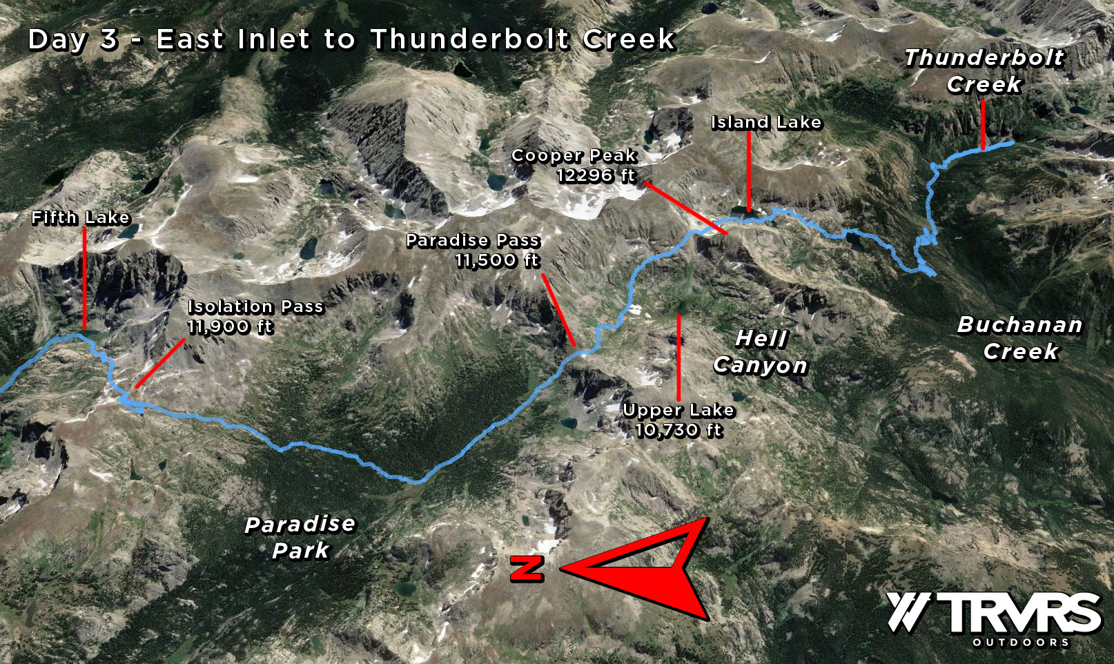
Tuesday, September 22nd -- Finishing up early the day before allowed me to get a good nights rest and I was lying awake in my tent at 5 AM. I unzipped my sleeping bag and reached for my GPS watch. Temperatures reached 37 degrees. Rain and snow were in the forecast in the days leading up to the trek and I was prepared to move slowly or take a zero day. Yet the only moisture present was in the form of condensation in my tent walls.
By 6:17 AM, I was on the trail and fifteen minutes later, I was back to negotiating blow downs and bogs. I was here only a month prior and although this portion of the East Inlet is known to be unmaintained, it was obvious that the recent storms did a number on the entire region. This went on for a little under a mile but I eventually emerged from the treeline below Fifth Lake. It was 8:15 by the time I reached Isolation Pass. I was moving notably slower than the previous days, but I may have lost a good amount of time taking photos of a couple of big horn sheep along the way.

Two Big Horn Sheep, holding their ground at 11,500 feet between Fifth Lake & Isolation Pass.
I planned to take advantage of past experience and climb the high route along the Contintental Divide. The Class 2 alternate route ascended Isolation, Ouzel, and Ogalalla Peaks before rejoining the Pfiffner at Cooper Peak Pass.
Opting for Paradise Park
Ultimately I decided against this in favor of seeing more new terrain. This would be a mistake since the descent toward Paradise Creek very quickly developed into hurdling my way over another dense forest of fallen trees. In spite of its difficulties, the Southern and lower portion of Paradise Park offered cool winds, serene fall colored meadows and a tranquility unmatched by any other portion of the Pfiffner Traverse.

Looking into Paradise Park from Isolation Pass.

Looking SE at Watanga Mountain from Paradise Creek.
Ascending the steep grassy northern slope of Paradise Pass was a little bizarre. Climbing upwards of 700 feet in under a half mile anywhere along the Sierra High Route usually meant scree or talus, but here I was traversing grassy meadows. It became uncomfortably warm about half way up, but I took my time and eventually made it into Hell Canyon where I waved goodbye to the Rocky Mountain National Park and its permit system.

Looking South at Paradise Pass from the meadows along Paradise Creek.

Paradise Pass.
Entering the Indian Peaks Wilderness
Cooper Peak Pass and its entire ascent were clearly visible from the top of Hell Canyon. The Skurka map suggested skirting the northeast shores of Upper Lake and then climbing directly toward the Pass. I opted instead to fill up on water and stay above 10,900 feet, traversing the series of shelves further north. This gradual approach bypassed what looked like a ton of scree and included ample sources of water along the way. The remarkable views further eliminated any question of whether or not this was the best choice.

Looking down into Hell Canyon from Paradise Pass.

Click here, to see this photo with a highlighted route.
Seeing Island Lake offered relief. Although I wouldn't describe the continued route as easy, it was good to be on a familiar terrain. The route crosses to the east side of the creek at Island Lake's outlet before descending further toward Gourd Lake. At the foot of the Lake, I made sure to take a long break and dip my feet in its waters. Ominous clouds began to form and I thought nothing of them. Half a mile into Buchanan Creek, I crossed paths with a day hiker who asked if I had run into any bears. He apparently saw a mother and her cub earlier that day. We parted ways and I continued upstream toward the Thunderbolt Creek confluence.
The campgrounds just past the confluence were extremely inviting but it was still early in the day and camping at Pawnee Lake seemed like a realistic goal. Just thirty minutes later, it began to rain. I took a second to layer up and assess the terrain. I had a clear view of the next pass and it didn't look inviting. The Skurka map used words like slabs, ramps, and ledges: none of which sounded particularly safe to climb in wet conditions. I also didn't know what to expect for shelter and wasn't sure that climbing to 11,700 feet was a good idea during potential thunderstorms. I stood there for all of ten minutes before deciding to head back to the previous campsites and calling it a day.

Looking South toward Paiute Pass from Thunderbolt Creek.

Falls before the ascent toward Paiute Lake.

Campsite near Thunderbolt Lake.
Day 4, Thunderbolt Creek to Caribou Lake
13.8 miles | +6,400 feet | -5,100 feet
Time on feet: 09:59

Wednesday, September 23rd -- It rained sporadically throughout the night and although I woke up twice with sleep paralysis after dreaming that a bear was circling my tent, I felt fairly well rested. By 8:28 AM, I was back to where I left off with clear blue skies above me. I paralleled the cascading falls of Thunderbolt Creek for nearly 700 feet before reaching Paiute Lake and being out of the treeline was a relief. I preferred granite to forested landscapes. It seemed more honest. Plus the sun was beginning to emerge from behind the ridge line and I was eager to soak in its warmth.

Paiute Lake from the top of the falls.

Looking up at the goal, Paiute Pass.
Entering Cascade Creek
Nearing the Pass, I felt confident that I had overcome the majority of previous obstacles with ease. As I reached the final approach however, I definitely pulled off some exposed class 3 moves. The top of Paiute Pass was small and steep on both sides. I wasted little time enjoying the view and made sure to peak over each ledge as I descended so as not to place myself in a position I couldn't get out of.
To my surprise, the Pawnee Pass trail was not littered with blow downs and I reached the Cascade Trail unscathed. I took out my map at this junction to see how much elevation I could expect from the next climb. I was in for a massive 2,400 foot ascent to the next pass and the Skurka map described it as the hardest feature along the entire Pfiffner Traverse. A passerby wearing jeans, sneakers and a white cotton tee walked along the trail with his leashed beagle and noticed the map I was now putting away.
"You need help?", he said with a thick southern accent.
"uh, I'm fine, thanks. I was just preparing myself for whats next."
"You're not far! The lake is just over a mile away."
I chuckled to myself, "Yeah, thanks."
Crater Lake Basin (holy hell)
Stepping foot into the Crater Lake basin was unreal. Its surrounding peaks and massive granite walls towered above it from all sides. Two realistic options for reaching the ridge line presented themselves but planning that far ahead started to overwhelm me, especially with potential storm clouds looming above. I pivoted my focus to ascending the granite walls north of the lake.

Arriving at Crater Lake Basin. This place was insane.
Even after climbing 1,500 feet, I still couldn't settle on the correct approach to the ridge line. The map described a "NE Gully", and although I could clearly see a gully further south, it was made up entirely of scree and didn't look particularly fun. I opted to follow the GPS file which lead up a chute further north. In hindsight, the scree slope would have been safer. Although there were solid granite holds throughout the ascent, there was also a lot of loose dirt and exposure on this arguable class 4 route. Andrew Skurka caught a
video I posted on Instagram and confirmed that the route chosen was not the correct way. I instead ascended the "Coin Slot". It was a "fun" alternative nonetheless.

NE gully, far left. My class 4 route, Coin Slot Chute, right. Whoops! That wasn't easy.
I topped out on the ridge line in an hour and fifteen minutes from the outlet of Crater Lake and after leaving the Coin Slot, I thought I'd take a minute to both message my girlfriend and change my underwear. It started to snow as I reached for my jacket. A small storm system was passing to the west. I skirted around Hopi Peak and quickly dropped down into the Lost Tribe Lakes where I felt much more comfortable.

Looking down at the Lost Tribe Lakes and the upper reaches of Wheeler Basin.
Wheeler Basin & Arapaho Creek
The thousand foot descent into Wheeler Basin wasn't particularly difficult, but my legs were starting to feel like Jell-o. I took my time and was extremely grateful to find a clear cut trail near the creek. This lasted for all of seven minutes before I was once again pummeled by a barrage of blow downs. The terrain became more steep and the obstacles more difficult, so I took another look at my map and suddenly realized why Skurka marked this section with the word "ford" after being unsure in previous reviews. I would descend directly over the cascading falls for nearly three hundred feet before leaving the creek and moving south toward Coyote Park. This was fairly straightforward, but as I reached Arapaho Creek the downed trees were by far the worst they had been up to this point.

Fording the falls for three hundred feet.
Navigating circuitous blow downs was becoming both mentally and physically draining. I kept veering west in hopes of landing on the Arapaho Pass trail, but after the third effort of crossing the creek and being turned around by a wall of fallen pines, I decided to abandon the effort completely. Soon after, I was walking atop a log and noticed a trail cutting across perpendicular to the tree. My eyes widened as I had finally found the Arapaho Pass trail, but when I looked off in each direction, there were just more trees. The path had been completely obliterated.
I followed the path to the best of my abilities, but by the time I reached Caribou Lake I was dragging my knuckles across the floor. The only shred of good news was that I would have zero problems finding a campsite. Sure enough, I arrived to a near desolate lake. The exception being three moose.

Camp at Caribou Lake.
Day 5, Caribou Lake to Berthoud Pass
24.1 miles | +7,700 feet | -6,900 feet
Time on feet: 12:22

Thursday, September 24th -- I spent the remainder of my time at Caribou Lake loading up on water even knowing I'd wake up throughout the night to urinate. I needed to catch up on hydration for several reasons:
-
I intended to bypass Caribou Pass/Columbine Lake and instead traverse Mount Neva. This meant that there wouldn't be a convenient place to filter water until I reached Rollins Pass (9 miles).
-
I was fairly certain that if I managed my resources and pace correctly, I could finish that day.
Although I didn't mind spending another night on trail, there was no convenient way to split up the mileage without having one extremely short day in comparison to my previous efforts. On top of that, I had already done this segment several times backpacking and trail running. The remainder of the route was fairly tame.
Climbing Mount Neva
I was on the trail by 8 AM and by 9:30 after taking a break near Lake Dorothy, I reached the north ridge of Neva. I wasn't completely sure I would make it across having done no research on the route, but figured a failed ascent wouldn't be much of a setback, especially since a quarter mile use trail connected the ridge directly to Caribou Pass. The route was comprised of a few class 3 moves and solid granite holds throughout. In hindsight it probably didn't save me much time, but if I saw another downed tree, I would have purposely impaled myself in one of its branches. It was a fun climb and totally worth the effort.

North Ridge of Mount Neva.
Nearing Mount Jasper, I ran into a trail runner who yelled out "Human!" I shared his enthusiasm and we both attempted to describe our cross country excursions to each other. Neither of us had any idea what the other was talking about and we both went on our way, but there was a shared mutual respect.
Catching the Continental Divide Trail
Just west of Devil's Thumb was the first of many wooden posts indicating that I had reached another portion of the infamous Continental Divide Trail and for the first time, the upper portion of the High Lonesome Loop trail. I took a break to admire the views above King Lake, then left the CDT for Moffat Road (County Road 80). I figured I would drop down into Pumphouse Lake to load up on water but as I reached its trail junction, an SUV pulled up from the south. I waved them down to ask if they saw any small streams along the road within the last mile. I remembered filtering right off of the road during a previous visit and I was at this point trying anything I could to finish the Pfiffner before days end.
The couple confirmed there was a stream ahead and the car drove off, exposing a parked four wheel drive golf cart with two cases of 16 oz water bottles in the back seat. It was like a scene out of a movie. I shamelessly took three bottles and went on my way. A half mile later, I found my trickling stream where I filled my belly and ascended cross country back to the CDT.
Entering the James Peak Wilderness
At 3:30 PM, I reached Roger Pass and I needed to make a decision on whether I should descend toward Heart Lake and call it a day or push through. If I ever needed mental reinforcement on the difficulties ahead, it was visible from this pass. Jame Peak dominated the foreground above the Jim Creek basin while Mount Bancroft and Parry Peak looked no less intimidating. I took a second to text my girlfriend and let her know that I'd be finished before 10 PM. She was an hour away in Golden.

Fear of dehydration set in on the James Peak ascent and I spent several minutes filling up my bottles with a mixture of snow and water. I must have carried 3 liters up to the peak, the most I had carried on the entire trek. It was a slog. I shuffled down the talus on the south slope and noticed that the CDT bypassed this entire segment due to the class 2 scramble west of Iceberg Lake ('Where ya going CDT? We were just beginning to have fun!').
I started getting back into gear around Parry Peak and the sun finally went down when I reached Mount Eva. At Flora, I realized that previous estimates for a 10 PM finish were way off and I texted my girlfriend that I'd be done closer to 8:30. I tumbled down the ski lift use trail and reached Berthoud Pass at 7:50 PM.
I had completed the Pfiffner Traverse and even though it wasn't what I had my heart set on, it was a fine substitute. I took pride in crossing one of Colorado's toughest backpacking routes off my list in under five days.

More Information About my Pfiffner Traverse Effort
Daily Efforts
All data below is approximate and based off of a
Coros Vertix altimeter watch combined with my consistent failure to stay on track.
| Date |
Starting Point |
Ending Point |
Distance (miles) |
Elevation Gain (ft) |
Elevation Loss (ft) |
Time on Feet (hours:minutes) |
| 09/20 |
Milner Pass |
Haynach Lakes |
9.5 |
3,200 |
3,200 |
06:25 |
| 09/21 |
Haynach Lakes |
East Inlet |
19 |
5,200 |
5,300 |
09:21 |
| 09/22 |
East Inlet |
Thunderbolt Creek |
16 |
4,200 |
5,300 |
09:31 |
| 09/23 |
Thunderbolt Creek |
Caribou Lake |
14 |
6,400 |
5,100 |
09:59 |
| 09/24 |
Caribou Lake |
Berthoud Pass |
24 |
7,700 |
6,900 |
12:22 |
Gear
Here is a
lighterpack build for a Sierra High Route attempt which fell through. The gear listed was created at least six months ago and doesn't reflect the gear I used on this trip since it hasn't been updated. But it should at least give you a general idea of what I brought.
Nutrition
I did not cook anything fore the entirety of this trek. The staples of my diet were calorie dense foods like granola, beef jerky, and dried mango. You can take a look at my entire
nutrition spreadsheet for more detailed information.
Total Food budgeted: 10.3 lbs, 4,974 calories per day.
Total Food consumed: 6 lbs overall, 2,800 calories per day.
If you like what you're seeing, please like, subscribe, share, and definitely
check out our shop to help support what we do. Thank you for reading.


Quite the adventure. I had twice attempted part of that, but starting from Berthoud Pass. The first time I twisted my ankle on the first day, the second attempt my hiking partner twisted his ankle. On another occasion I hiked up Hell Canyon, then into Paradise Park and back down the Grand Lake. Separate hikes to Gourd Lake and another to Crater Lake. Been up Mt. Ida and across Flattop. My great uncle was a serious climber. He led the first woman up Lone Eagle Peak above Crater Lake and he was the 7th person to ever climb all 14,000 foot mountains. I appreciate your post. Thank you.
Awesome trip report! Great to see some recent pictures on some of these features as I’m about a month out from my own section on the Pfiffner. Are the pictures taken with your phone or the gopro?
Leave a comment